
An Archaeological Context For Understanding John 4:20 -- By: Robert J. Bull
Journal: Bible and Spade (First Run)
Volume: BSP 05:2 (Spring 1976)
Article: An Archaeological Context For Understanding John 4:20
Author: Robert J. Bull
BSP 5:2 (Spring 1976) p. 57
An Archaeological Context For Understanding John 4:20
Drew University
While at Jacob’s Well and during the course of an argument with Jesus about the proper place to worship God, a Samaritan woman exclaimed, “Our fathers worshiped on this mountain,” and thereby directed attention to Mt. Gerizim. It has been assumed that she was referring to the mountain in general as the location of Samaritan worship. Recent archaeological discoveries suggest instead that she was directing attention to a particular place on Mt. Gerizim and that her reference to the termination of Samaritan worship in the past may have been attached to the ruins visible to Jesus and herself as they talked at the well.
The eastern slopes of two of the five major peaks of the sprawling mountain rise from beside the current traditional site of Jacob’s Well and a little to the south of nearby Tell Balatah where lie the remains of the city of Shechem, the erstwhile chief city of the Samaritans (see the map). From both well and tell, the higher (elevation 2858 ft.) and more distant of the two peaks can be seen, its rocky slopes devoid of trees. At its summit, the tomb or weli of Sheikh Ghanim, built on the northeast corner of a fortification the Emperor Justinian (A.D. 527-65) had constructed to protect the 5th century octagonal Theotokos church from Samaritan attack, is the one building visible. (It is Procopius of Caesarea who reports on the work of Justinian, in his De Aedificiis V. 7.)
A hundred yards south of the weli on the same summit is a flat rock which the Samaritan community has designated as the place where their temple once stood (see the map, and photo on page 59). The nearer and lower of the two peaks (elevation 2727 ft.), however, is the one which looms immediately above anyone viewing the mountain from Jacob’s Well or from the nearby remains of the destroyed city (see photo on page 60). This peak, representing the northernmost extension of Mt. Gerizim, is now partly covered by a
BSP 5:2 (Spring 1976) p. 58
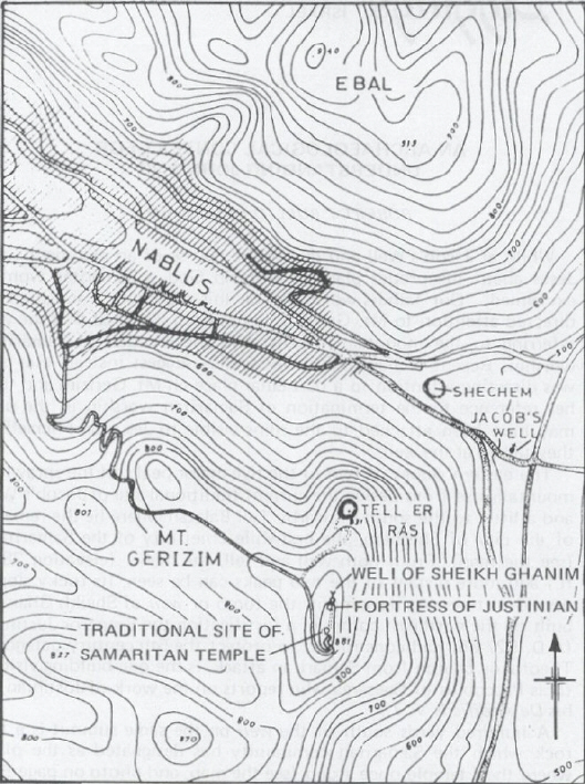
Map of Mt. Gerizim and Mt. Ebal with the Nablus-Shechem Valley between them, locating Tell er-Ras and the site of Jacob’s Well. Drawn by O. Unwin and adapted by S. Karman.
BSP 5:2 (Spring 1976) p. 59
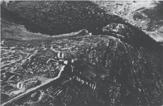
Aerial view of two peaks of Mt. Gerizim, looking north past the summit toward Tell er-Ras. From tower left to upper right, the numbers indicate 1) the traditional site of the Samaritan temple; 2) the weli of Sheikh Ghanim on the NE corner of the Justinian fortification enclosing th...
Click here to subscribe